Sunday, April 19, 2015

Back to Flores and Kelimutu volcano

Entering the stretch run of field work, we were joined by my lovely wife Maggie.  We began in central Flores in the town of Ende and visited four stations. Three were working in perfect order, and one was having multiple problems.  Three visits later, one severed GPS cable and a recharging of the battery, and some issues with a torrential downpour led to a successful stabilization of our station near Borong
Maggie in full supervisor mode.  Full immersion in mud
was required to restore this station.
This hard battle provided excellent context to take a short detour towards Kelimutu National Park.  Absolutely spectacular.  This volcanic center hosts three crater lakes of different colors, representing one of the well-known jewels of the Nusa Tenggara province. Starting from the adjacent village of Moni at 5am, we made it to the top of the park for a misty sunrise.  A bit later, the sun cracked through and the volcano was revealed in full glory. 

Nova and Maggie


The central crater lake

Central and lower lake


Monday, April 13, 2015

Alor Island and the edge of the volcanic gap

Our travel to Alor Island - the northeastern edge of our Indonesia array - brought us to visit stations on the extreme ends of the land mass.  This island is particularly interesting for our research because while the composition is clearly that of relatively young volcanic activity, there are no active volcanoes present.  This sudden (spatial) paucity in volcanism is attributed to the collision of Australia's northern margin with the young volcanic islands of Banda between Alor (west limit) and Damar Islands (east limit).  As we flew back from Alor on the way back to Kupang, a good overhead view of the easternmost active volcano was available, Gunung Sirung on Adonara Island:

View looking SW over Sirung - the edge of the volcanic gap!
Travel across Alor was remarkable.  The landscape is much more lush than during the dry season, including grasses on the rocky areas and floodplains, and dense vegetation in the high, wetter portions.  During the installation last year, we viewed sections of eucalyptus trees that were barren of leaves, displayed beautiful white trunks, and were underlain by black, rocky soil (see archive of posts for photo).  During this season, it looks much more inviting:


We were fortunate to drive to both ends of the island, find both stations to be performing in good health, and do it all in one day!  So, now we have serviced 14 stations with 8 remaining.  I am off today to go meet my lovely wife Maggie in Denpassar, and then back to the field tomorrow to cover four stations in west Flores Island.  It looks like we have a good plan to finish off the field work while also taking in a few tourist excursions.  Look for updates on these adventures in future posts...

In west Alor, a view over a well-known snorkeling spot was appealing.

Friday, April 10, 2015

East Flores and Lembata

After an afternoon arrival in Maumere, Flores Island, we reunited with our primary driver from last year's installation.  We set out to the east, serviced one station along the way, and took in the scenery of the volcanic arc.  The contrast between the outer arc islands of Timor and Sumba against the volcanic arc islands of Flores, Lembata, and Alor is a central theme of our geologic and geophysical investigation of this part of the Banda region.
After an overnight stay in Larantuka and multiple reconfigurations of our travel plans (due to elusive and/or faulty info on travel schedules) led us to arrive on Lembata Island on day two.  We managed to visit the station closest to Lewoleba (Lembata's capitol), making it three stations in 2.5 days.  The next morning, we made it to Baopukang - host to one of the most scenic stations in the array.

Nova taking notes of the station's
excellent performance.
Station BAOP after servicing and data collection that included a far bit of gardening.
The view westward across the Lembata Strait is especially enjoyable after finding
the equipment in good condition and not being on the edge of heat stroke!
Thunderclouds piling up over land masses are surreal at times. 
Satisfied after a solid run through strongly performing stations, we had an opportunity to visit a local fabric weaver.  The property was full of local orchids, small ponds, lots of whale bone artifacts (Lembata is one of a few places worldwide that still practices whale hunting), and naturally harvested pearls. Our driver, Julius, let a VERY vocal cockatoo our of its cage, provides this terrific photo:


Monday, April 6, 2015

Finished in Timor

All stations on Timor Island are now serviced and data all collected.  Nearly everybody felt the 27 February, 2015 Flores earthquake (see previous posts), so we put together a one-page display of data along with a map of stations and earthquake locations.  Nova has been presenting these results and been receiving great interest from locals, all while marveling at the phenomenon of earthquake wave propagation.  The graphic shows two earthquakes (Flores and 17 March, 2015 Molucca Sea event) that were recorded at five stations (one on Timor, four on Sumba).

Vertical channel recordings from two recent earthquakes.
The Flores event (top left) is shown on the scale of minutes (satu menit = one minute),
the Molucca event (bottom right) is on the scale of seconds (sepuluh ditek = ten seconds).
It is always informative to see the same earthquake recorded at different locations...
On the way to the south coast of Timor Island, near the village of Kolbano, we visited a station that was installed by Cooper and Nova last year.  It was running quite well, and the hosts were interested to see how our project was coming along.  This was Nova's first opportunity to show the graphic above.  
We headed to the northeast through Kefamenanu, and then on to one of the most remote stations in the array - Betun village.  The scenery is spectacular, especially this time of year when it is so lush and green.  Passing through the outskirts of Betun, large ficus(?) trees grow along the roadway with tendrils from above reaching back down to Earth.


We managed the data download and improved the health of the Betun station.  It was quite hot, enough to generate another massive sweatfest.  But hey, it had been over a week since I was last on the brink of heat stroke, so I was due to be tested.  Sparing further detail, we finished up and moved on to showing the data.  The whole village had assembled by this time, providing an excellent audience.

Nova delivers 'the goods'


Saturday, April 4, 2015

A different shade of Sumba

Last year, our installations on Sumba island took place during hot weather, including heroic efforts to dig holes (with much help from locals!), and a dry and brown landscape.  After learning more about the dynamic (yet uncertain) geological history of the island, we were especially eager to gather data and have a look at the results.

A successful data collection in SE Sumba, Melolo village.  Cooper and Nova
talkin shop while Rosie the Chiseler and the land owner look on.  Rosie's
daughter looks on, proud of her newly acquired fresh bottle of water.  
We left Melolo to wrap up the day along a narrow walking pathway that we took advantage of during our installation last year.  It clearly is used primarily for walking and motorbike thoroughfare, but we didn't mind powering through with Ule and the Sandlewood Hotel 4x4 (not misspelled):

Yeah, thats right. With a 'Fear Factor' window sticker, who could be afraid?
Two stations working well in west Sumba, one night at the Sandle Wood, then on to central and eastern Sumba.  We made it to central Sumba at Kambapari village, collected data from a well-functioning station, and presented some preliminary views of the data to the office staff.  We found the 27 February, 2015 event north of central Flores Island that was felt by all.  Nova effectively communicated our success as well as our thankfulness for their hosting of our equipment, and then we moved on to the final Sumba station.  So far, four stations in Indonesia had been visited, four working flawlessly. Time for a dose of reality.
We arrived in Waitabula, and on to the adjacent village of Loura to check on our station. It had been overgrown by grass, a large pile of rocks were dumped nearby, and a fence had been installed a few meters away.  This lack of maintenance was due to a change in the village leadership that occurred at the turning of the new year - a change that we discovered on the way to the station when we visited the old Camat to inform him that we were back.  Most likely, none of these causes for concern provided any problems.  But...the station was not performing well. Clear misbehavior of the seismometer sent us reeling into worry.  We tried to fix it by recentering, checking the power system, opening up the sensor vault and releveling - but could not achieve a suitable result.  Frustrating.  We know this is a critical location, Sumba is a key island to understand within our research goals.  After spending time thinking through options and reviewing data recorded by the station, we pulled the equipment and took it back to the hotel for overnight testing.  Cooper ran the station in his room overnight so that we could have a more careful look at its performance in the morning.  While it was not perfect, it was clear that the seismometer was working good enough to put it back into operation.  Not only did the background data look suitable, but a few earthquakes were clearly recorded overnight!  So, it was that much more obvious that we should put it back to work.  In the morning, we headed back to Loura to re-install:

Without proper protection to transport our delicate
instrument, Cooper became the 'seismometer whisperer'
We efficiently reinstalled the equipment and had time to go back to the hotel for lunch.  The only option for us to move on was for Cooper to stay in Waitabula to catch a morning flight back to Bali while Nova and I flew back to Kupang in the afternoon.  So we had one last meal together, sorted out final logistics, picked up some sweeet textiles specific to east Sumba, and went our separate ways.  The flight back to Kupang provided a spectacular view of the western Savu Sea, north Sumba Island, and Flores Island.  There is a local legend in Sumba that their island and Flores were connected by a land bridge that communicate culture between the two.  It is an understandable thought, even from our scientific view - the sea bathymetry is especially shallow between the closest points on each island, and there are peninsulas on each island that point toward one another.  These can nicely be seen in this north-looking photo taken on the flight back:

The northern horn of Sumba, pointing toward Flores Island.
A south-pointing peninsular jutting off Flores reaches back to Sumba.
A truly great view, our station NAPU is in the foreground, and a
terrific view of a growing thunderstorm over Flores can be seen.  What a landscape!


First station revisited in Indonesia

Upon Cooper and I arriving in Kupang, Indonesia, we reunited with Nova Roosmawati to make the tour through our 22 stations currently operating in the province of Nusa Tenggara Timur (NTT).  Last year, during our installation phase, it was hot and somewhat dry.  In March, the wet season has completed and it is green and lush, and the temperature is noticeably cooler.  Perhaps even more helpful is the fact that it is the down season for tourism, both within Indonesia and internationally.  It is a pleasure to be back in our field headquarters!
We first visited a station in Timor that is a four hour drive from Kupang (this time of year...), the small village of Lelogama. Last year's installation has a brutal and adventurous seven hour drive that included a near collapse of a bridge.  We learned that a truck had blocked the same bridge about a week ago when it reportedly partially sunk into a section of the span.  We received info that it was passable and arrived in Lelogama 3.5 hours later.  This was our first servicing and data collection of the equipment that is loaned to our project from the U.S.-based IRIS-PASSCAL instrumentation center.  We are happy to report that the station was working flawlessly!

The office sign at the Camat office, identifying
the 'county' (Kapubaten Kupang), the village group
(Kecamatan Amfoang), and the village (Lelogama).
We traversed the rough road to Lelogama in style, a beastly Toyota Hilux 4x4.  The scenery is beautiful, and the geology is spectacular.  Our trip started in the perched coral terraces in Kupang, travelled through a large section of the enigmatic Bobanaro Melange (this geologic unit deserves an entirely separate blog entry), and ended in volcanic and carbonate rocks that belong to the infamous Banda Terrane.

Our parking spot for lunch.  Tidak masala (no problem) traversing the roads!  

Timor Leste and the Crocodile

The multi-cultural composition of Timor Leste gives rise to many legends of natural phenomena.  Across the range of unique geographic regions of the country, admiration towards the ancient reptile is ubiquitous.  In fact, a common legend is that of The Crocodile Story (check out this link further for more Timor Leste history). The shape of the island is commonly described to resemble the crocodile.

Timor Island, half Indonesia (west) and half Timor Leste.  
Visits in March 2014 and 2015 provided opportunity to see
crocodile in the eastern part, between stations TL06 and TL08.

On our return trip from Los Palos - the easternmost station in the array - we saw a croc swimming upriver.  We had successfully reinstalled a repaired seismometer in Viqueque and collected data is Los Palos before heading back to Dili. Pulling aside on the bridge crossing a small river:

In middle of river, the head and part of back is exposed.


Friday, March 27, 2015

Another earthquake clearly recorded in Timor Leste

While making our data collection run, we are rewarded with sneak peeks of the data we so diligently work to gather.  A significant event occurred mid-way through our time in Timor Leste that occurred ~1200 km north of our array.  

The 17 March, 2015 Molucca Sea event (Mw6.2, 46km deep) taken from the USGS summary page
We visited four stations after this event happened, giving us seismologists a dose of instant gratification!  Well deserved, according to my sweaty, sunburned opinion.

Vertical channel record from stations in Timor Leste.  The P-wave is very
clear as the first arriving energy (look at time axis on bottom of page)
around 22:15, and the surface wave shows up around 22:18.
No S-wave?  Why not (trick question)???????
(top to bottom) Oecussi, Maliana, Same, Los Palos


Wednesday, March 25, 2015

Mechanics on to go ...

From a special guest writer:


The roads in Timor Leste are pretty rugged by anyone's standard and transporting delicate machinery to such beautiful but isolated locations is always something of a worry (check out the road on the map above !) In these photos Leland is preoccupied with the exhumation of the instrument in Same (in central TL) somewhat concerned that the original road trip might have been a bit hard on it and we had to work some mechanical problems ... who knew this would be foreshadowing ....


On the way back to Dili from Same, the views of the topography along the main highway are perfectly spectacular with many opportunities to look down shear drops from the window of the rapidly moving car. Two intense days of driving were beginning to wear on everyone and everything. The Land Cruiser was flashing oil-pressure warning signs as our driver raced up the hills. With a nod to the medieval surgeons, the driver decided that this meant we should bleed off some oil. Having pulled out the oil filter and run the engine for a while, splattering oil everywhere, and satisfied himself that the car was cured, he drove a few hundred meters before the engine threatened to die. We coasted to a nearby house and transfused a bottle or two of fresh oil.

But there are spectacular views as the road hugs the mountainsides and crosses the high passes between broad valleys.  This south-looking photo brilliantly captures the dynamic geology of Timor - on the left, the Cablac Mountain front is formed by an active normal fault, while the topography on the right leads to the highest point on Timor (Mt. Ramelau).  The structure of Ramelau is composed of variably faulted sedimentary sequences of the Gondwanan and Australian margins whereas the Cablac (broken?) Limestone is associated with the Banda terrane that has been thrust over the top of Timor.  Two drastically different origins, multiple phases of deformation and structural geometries,  one dynamic landscape...

Oecussi upgrade

The western enclave of Timor Leste, Oecussi, is an important region for the country. This area was the original landing point for the Portuguese on Timor Island, and was their first official colony (ca. 1702).  Following Timor Leste's independence from Indonesia in 2002, Oecussi remained with the Timorese.  The area hosts a geologic configuration much different than the rest of the country.  Here it is primarily composed of Banda Arc volcanic rocks - pillow basalts, tuffs, and volcanic breccias - that were derived from hundreds to thousands of kilometers to the north.  The backdrop of the photo below shows the basalts cloaked in the darkness of a looming storm.  Overall, the volcanic terrain looks much like picturesque photos of Hawaii, lush vegetation lines rugged, incised slopes.


Luis Teofilo wrapping up the new and improved Oecussi station.
We came to the Oecussi station that was originally installed in the province capitol, Pante Macassar. Based on previous on-site assessment and careful examination of the data, we were set on moving the station to a more quite location.  Too much local traffic and too close to the ocean (noise).  
We headed to a beautiful location four kilometers to the south in the village of Bobkase.  IPG director Eugenio Soares talked with local IPG staff and a nearby landowner to find us a suitable location. By this time, it was about 10:30am and the temperature was on the rise.  A max temp of nearly 40 C, Cooper and I spending 3 hours on the brink of heat stroke, and a few shovels in the ground led to a sweeeeet installation.  We can truly say we earned this one.

Wednesday, March 18, 2015

Some like it hot!


Near the town of Pala on the island of Atauro, there is a group of intertidal hot springs from which we collected samples for a project aiming to build a global chemical database of hot spring waters. Luis and Dr. Larry are working to extract the water (with a plastic syringe) and squirt it into a jar. They have to be careful though because the water is a piping ~60 degrees Celsius!


The water flows right out of the ground and the source is physically accessible for sampling only during low-tide. Imagine a gentle, steamy water fountain that has low pressure and would require you to kiss the spout to get a drink.

In order to better understand the geology of the hot spring, Dr. Larry took to smashing some of the in-place igneous rocks and our team (from left: Luis, Cooper and Meghan) gathered round to describe and name the rock and its constituent minerals. 

Some friendly locals stopped by to smile and watch our sampling and rock battering deeds. Apparently, local fishermen and fisherwomen will cook their catches directly in the springs! It's certainly believable - that water was scalding. 

Dawn of a new data

Like this Atauro Island fisherman hauling in his early morning catch, we are in the initial stage of data collection.  After collecting a beautiful set of data from Dare village, a trip from Dili across the Wetar Strait to Atauro yielded another batch. Now, onward to the remaining 28 sites.  


Sunrise on Atauro Island.

Saturday, March 14, 2015

Transit to Dili, Timor Leste

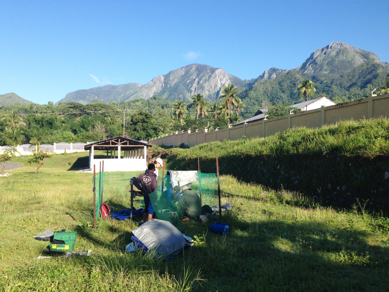
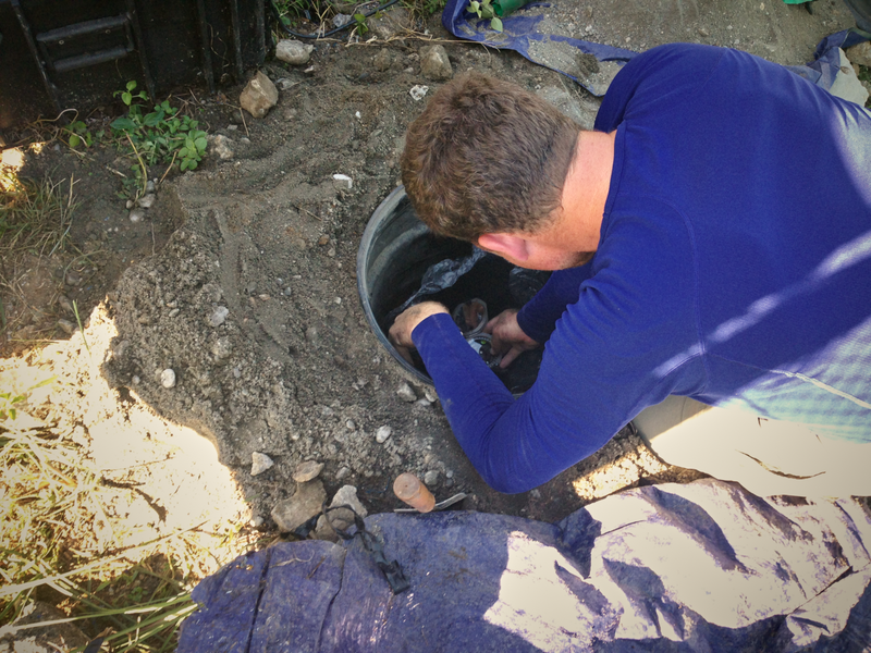
After a four month break from field work we are back to visit the seismic array.  Over the course of the North American winter, we have built an archived database of our experiment (hosted by IRIS-DMC), explored lots of scientific literature about our study region, and moved ahead with multiple grant-writing efforts.

This field season marks the growth of our interaction with IPG in Dili. Our entire USC seismic field team has assembled: ASSOCIATE professor Miller (congrats to Meghan and the USC Earth Science Department for promoting her!), Cooper Harris, and Leland O'Driscoll are all in attendance for the first time in Timor Leste.  We also have the pleasure of traveling with Louis Moresi for the week.  Should prove to be an excellent start to the field season.

We have lots of other items to report in greater detail, but here are few highlights of the aforementioned items:

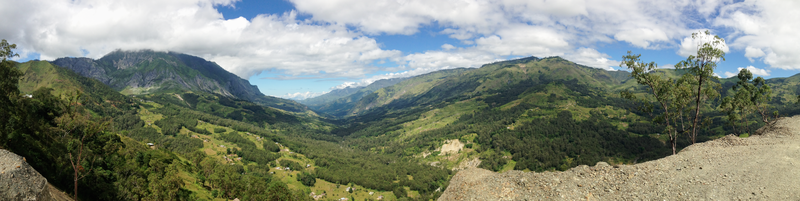
- The current academic term at USC has allowed us to explore various topics of geologic and geophysical research in the Banda region.  The PIs of the project (Miller, Becker, and West) have organized a course that has led us to much better appreciate the dynamic and complex nature of Banda.  Their efforts have allowed the participants (Max Dahlquist, Cooper Harris, Adam Holt, Rob Porritt, Leland O'Driscoll) to tackle diverse and competing hypotheses on the regional geologic composition.  

- We have developed grants to extend our efforts in the region, with specific focus on facilitating hazard reduction and enabling longer-term goals of earthquake monitoring in Timor Leste.  We are competing to obtain a grant from the Society of Exploration Geologists within their Geoscientists Without Borders program.  

Stay tuned for updates from the field...